Showing posts with label Australia. Show all posts

Saturday, 28 May 2022

Why are kangaroos being spotted in India?

 When villagers walking along a road on the edge of a forested village in eastern India first saw three confused, weak and hungry animals, they couldn't believe what they were witnessing.

The animals looked nothing like anything they had seen before. They alerted West Bengal state's forest officials, who told them that the animals were kangaroos - native to Australia but not found in India.


The animals were rescued and sent to a wildlife park to be treated. One died later. The villagers were still confused and surprised by what they had seen. Soon, videos of the kangaroos in India went viral.


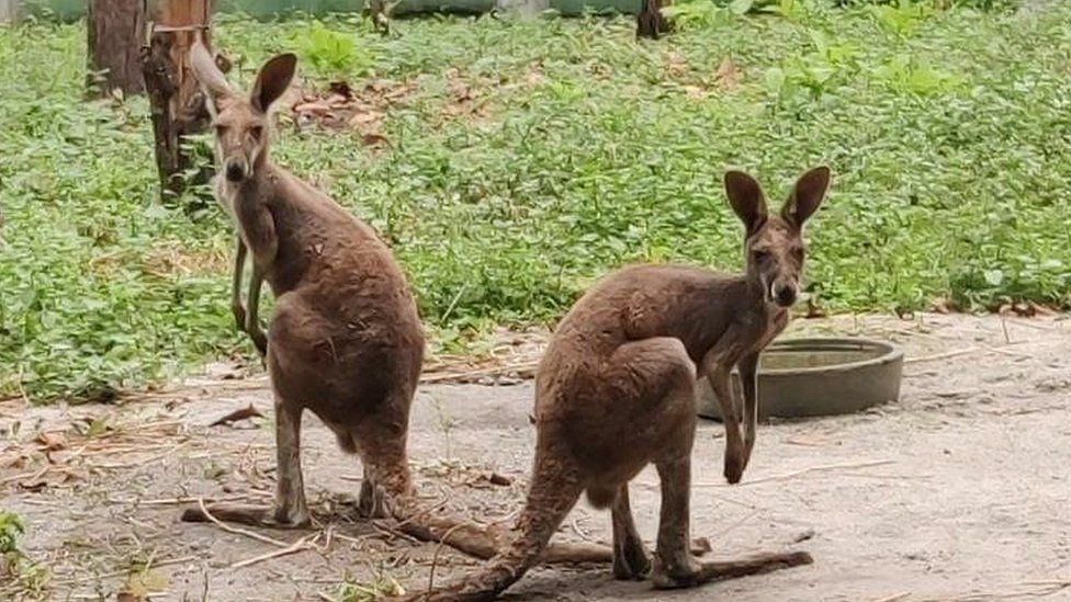
Wildlife officials say kangaroos are among the exotic animals smuggled into India. Bengal Safari Park


"How on Earth are kangaroos turning up in West Bengal," a Twitter user asked.


Debal Ray, the chief wildlife warden of West Bengal, tells the BBC that the animals were most likely left in the open during an anti-smuggling operation by his team.


When he received a tip-off that some exotic animals were being smuggled into the state, he immediately alerted his team. Acting quickly, the officers started checking vehicles along one of the main routes to enter the state.


"The smugglers probably got wind of it, and abandoned the animals on the highway," Mr Ray said.


"They probably ended up here from private breeding farms in southeast Asia," Agni Mitra, deputy director of the regional Wildlife Control Bureau, told the BBC, adding that smugglers often bring non-native, exotic animals to India's border states through Myanmar.

India's anti-smuggling intelligence agency, the Directorate of Revenue Intelligence (DRI), said that the country has seen a rise in demand for exotic animals.


Animals from Bangkok, Malaysia and other "top tourist destinations in South East Asia" are smuggled into the country and make their way to cities across India, it added.


Mr Mitra said smugglers use the "north-eastern corridor" to bring in exotic animals, ranging from a golden-headed lion tamarin, an endangered primate found only in Brazil, to threatened lemurs.


Indian wildlife officials often find that they can't prosecute these smugglers or traders because India's Wildlife Protection Act doesn't protect non-native, exotic animals.


Customs officials have the authority to stop people from transporting wild animals if they don't have proper permits. But they find it difficult to track illegal trade through porous borders.


The DRI said that since there is a ban on trade of native animal species, smugglers have shifted to "exotic species, which has led to disastrous global environmental consequences".


Wildlife activists say owning an exotic pet is considered prestigious - a trend that has only become more popular in recent years.


"A little while back, Zebras were seized in Bangladesh which were destined for a private zoo in India," Shubhobroto Ghosh, an activist with the group World Animal Protection said. "People are doing crazy things."


Indians have long had a liking for exotic animals.


In June 2020, India's Ministry of Environment, Forest and Climate Change announced a voluntary disclosure scheme, asking people to declare their exotic pets.


It said pet owners without proper documentation would not be prosecuted. The government wanted to "develop an inventory of exotic live species" in the country and streamline import procedures.


By early 2021, the government received 32,645 disclosure applications which listed exotic animals such as critically endangered lemurs, iguanas, macaws and even kangaroos, reported IndiaSpend, a data analysis website.


Wildlife officials said that despite an uptick in the number of exotic animals being brought into the country as pets, there was still no effective legislation to monitor the trade.


In 1976, India adopted the Convention of International Trade in Endangered Species (CITIES), an agreement ratified by 183 countries, which protects and monitors the trade of endangered plants and animals.


But the country has still not given the multilateral treaty any teeth - it can't be implemented under Indian law.


Lawmakers are reviewing an amendment to India's Wildlife Protection Act which would bring exotic flora and fauna, and other species protected by CITES provisions under wildlife authorities.


But Mr Ghosh is sceptical of its impact.


"Say I am a forest warden and I am your friend, and you have some rare primates from Brazil that you want to keep in your private zoo, you could very well just bribe your way through and get your permit," he explains.


"A lot of zoos unfortunately are becoming a part of this network - where traders and breeders work together to buy animals, sometimes non-native, exotic ones," Mr Ghosh added.


In April, two men were arrested when a red kangaroo was found in their truck during a routine police check on a highway close to West Bengal's border with the north-eastern state of Assam.


The men told forest officials that they had been handed these kangaroos at a farm in Mizoram, another state in the north-east, to be taken to a zoo in the central Indian state of Madhya Pradesh.


"They produced a supply order from the zoo, and the zoo even confirmed it," Mr Mitra said.


The zoo's curator told a news website that they had been "offered the consignment as a gift".


"Clearly this is a case of smuggling - the supply order was in the name of a farm in Mizoram, which does not even exist," Mr Ghosh said, explaining that under CITES provisions, protected animals have to be declared on a government website.


"There is no declaration of any kangaroos from any farm in Mizoram in government records," Mr Mitra said.


Meanwhile, the two kangaroos - Alex and Xavier - rescued by forest officials are being treated in the Bengal Safari Park, and are making good progress.


"They have some muscle atrophy, which is common in kangaroos when they are squeezed into small spaces while being smuggled," Mr Ray explained.


"If they feel at home, maybe we can display them [to the zoo-going public]. But they have to spend their life in a zoo. We cannot release them into the wild as India is not their natural habitat."


(Source: BBC)

Saturday, 1 January 2022

The missing continent it took 375 years to find

It took scientists 375 years to discover the eighth continent of the world, which has been hiding in plain sight all along. But mysteries still remain.

It was 1642 and Abel Tasman was on a mission. The experienced Dutch sailor, who sported a flamboyant moustache, bushy goatee and penchant for rough justice – he later tried to hang some of his crew on a drunken whim – was confident of the existence of a vast continent in the southern hemisphere, and determined to find it.


At the time, this portion of the globe was still largely mysterious to Europeans, but they had an unshakeable belief that there must be a large land mass there – pre-emptively named Terra Australis – to balance out their own continent in the North. The fixation dated back to Ancient Roman times, but only now was it going to be tested.


And so, on 14 August, Tasman set sail from his company's base in Jakarta, Indonesia, with two small ships and headed west, then south, then east, eventually ending up at the South Island of New Zealand. His first encounter with the local Māori people (who are thought to have settled there several centuries earlier) did not go well: on day two, several paddled out on a canoe, and rammed a small boat that was passing messages between the Dutch ships. Four Europeans died. Later, the Europeans fired a cannon at 11 more canoes – it’s not known what happened to their targets. 


Abel Tasman arguably did find the great southern continent, though he didn’t realise 94% of it is underwater (Credit: Alamy)


And that was the end of his mission – Tasman named the fateful location Moordenaers (Murderers) Bay, with little sense of irony, and sailed home several weeks later without even having set foot on this new land. While he believed that he had indeed discovered the great southern continent, evidently, it was hardly the commercial utopia he had envisaged. He did not return.


(By this time, Australia was already known about, but the Europeans thought it was not the legendary continent they were looking for. Later, it was named after Terra Australis when they changed their minds).

Little did Tasman know, he was right all along. There was a missing continent.


In 2017, a group of geologists hit the headlines when they announced their discovery of Zealandia –Te Riu-a-Māui in the Māori language. A vast continent of 1.89 million sq miles (4.9 million sq km) it is around six times the size of Madagascar.


Though the world's encyclopaedias, maps and search engines had been adamant that there are just seven continents for some time, the team confidently informed the world that this was wrong. There are eight after all – and the latest addition breaks all the records, as the smallest, thinnest, and youngest in the world. The catch is that 94% of it is underwater, with just a handful of islands, such as New Zealand, thrusting out from its oceanic depths. It had been hiding in plain sight all along.


"This is an example of how something very obvious can take a while to uncover," says Andy Tulloch, a geologist at the New Zealand Crown Research Institute GNS Science, who was part of the team that discovered Zealandia.

But this is just the beginning. Four years on and the continent is as enigmatic as ever, its secrets jealously guarded beneath 6,560 ft (2km) of water. How was it formed? What used to live there? And how long has it been underwater?


A laborious discovery

In fact, Zealandia has always been difficult to study.


More than a century after Tasman discovered New Zealand in 1642, the British map-maker James Cook was sent on a scientific voyage to the southern hemisphere. His official instructions were to observe the passing of Venus between the Earth and the Sun, in order to calculate how far away the Sun is.


Possibly due to a quirk of geology, the enigmatic kiwi bird’s closest relative hails from Madagascar (Credit: Alamy)


But he also carried with him a sealed envelope, which he was instructed to open when he had completed the first task. This contained a top-secret mission to discover the southern continent – which he arguably sailed straight over, before reaching New Zealand.


The first real clues of Zealandia's existence were gathered by the Scottish naturalist Sir James Hector, who attended a voyage to survey a series of islands off the southern coast of New Zealand in 1895. After studying their geology, he concluded that New Zealand is "the remnant of a mountain-chain that formed the crest of a great continental area that stretched far to the south and east, and which is now submerged…". 


Despite this early breakthrough, the knowledge of a possible Zealandia remained obscure, and very little happened until the 1960s. "Things happen pretty slowly in this field," says Nick Mortimer, a geologist at GNS Science who led the 2017 study.


Then in the 1960s, geologists finally agreed on a definition of what a continent is – broadly, a geological area with a high elevation, wide variety of rocks, and a thick crust. It also has to be big. "You just can't be a tiny piece," says Mortimer. This gave geologists something to work with – if they could collect the evidence, they could prove that the eighth continent was real.


Tasman’s ships left New Zealand after a bloody encounter with the Māori people – but he believed that he had found the legendary southern continent (Credit: Alamy)


Still, the mission stalled – discovering a continent is tricky and expensive, and Mortimer points out that there was no urgency. Then in 1995, the American geophysicist Bruce Luyendyk again described the region as a continent and suggested calling it Zealandia. From there, Tulloch describes its discovery as an exponential curve.


Around the same time, the "United Nations Convention on the Law of the Sea" came into force, and finally provided some serious motivation. It states that countries can extend their legal territories beyond their Exclusive Economic Zone, which reaches 200 nautical miles (370km) out from their coastlines, to claim their "extended continental shelf" – with all the mineral riches and oil this encompasses.


If New Zealand could prove that it was part of a larger continent, it could increase its territory by six times. Suddenly there was an abundance of funding for trips to survey the area, and the evidence gradually built up. With every rock sample that was collected, the case for Zealandia improved.


The final flourish came from satellite data, which can be used to track tiny variations in the Earth's gravity across different parts of the crust to map the seafloor. With this technology, Zealandia is clearly visible as a misshapen mass almost as large as Australia. 


Satellite data can be used to visualise the continent of Zealandia, which appears as a pale blue upside-down triangle to the east of Australia (Credit: GNS Science)


When the continent was finally unveiled to the world, it unlocked one of the most sizeable maritime territories in the world. "It is kind of cool," says Mortimer, "If you think about it, every continent on the planet has different countries on it, [but] there are only three territories on Zealandia."


In addition to New Zealand, the continent encompasses the island of New Caledonia – a French colony famous for its dazzling lagoons – and the tiny Australian territories of Lord Howe Island and Ball's Pyramid. The latter was described by one 18th-Century explorer as appearing "not to be larger than a boat."


A mysterious stretching

Zealandia was originally part of the ancient supercontinent of Gondwana, which was formed about 550 million years ago and essentially lumped together all the land in the southern hemisphere. It occupied a corner on the eastern side, where it bordered several others, including half of West Antarctica and all of eastern Australia.


Then around 105 million years ago, "due to a process which we don't completely understand yet, Zealandia started to be pulled away", says Tulloch.


Continental crust is usually around 40km deep – significantly thicker than oceanic crust, which tends to be around 10km. As it was strained, Zealandia ended up being stretched so much that its crust now only extends 20km (12.4 miles) down. Eventually, the wafter-thin continent sank – though not quite to the level of normal oceanic crust – and disappeared under the sea.


Despite being thin and submerged, geologists know that Zealandia is a continent because of the kinds of rocks found there. Continental crust tends to be made up of igneous, metamorphic and sedimentary rocks – like granite, schist and limestone, while the ocean floor is usually just made of igneous ones such as basalt.


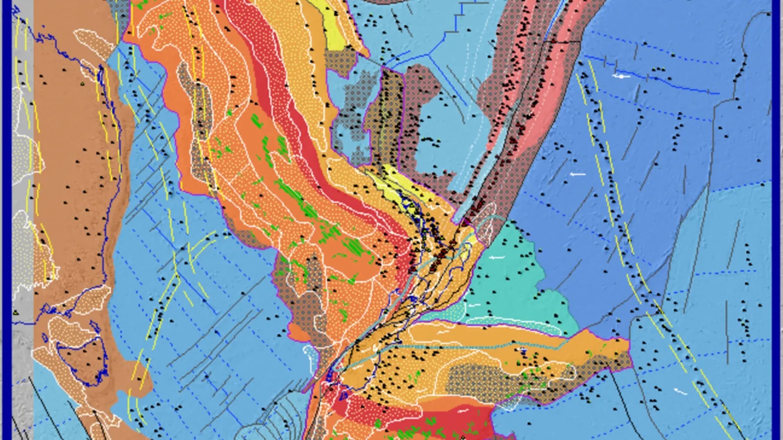
The red band of rock – the Median Batholith – should travel all the way down Zealandia in a diagonal line, but instead it has been twisted out of shape (Credit: GNS Science)


But there are still many unknowns. The unusual origins of the eighth continent make it particularly intriguing to geologists, and more than a little baffling. For example, it's still not clear how Zealandia managed to stay together when it's so thin and not disintegrate into tiny micro-continents.


Another mystery is exactly when Zealandia ended up underwater – and whether it has ever, in fact, consisted of dry land. The parts that are currently above sea level are ridges that formed as the Pacific and Australian tectonic plates crumpled together. Tulloch says opinion is split as to whether it was always submerged apart from a few small islands, or once entirely dry land.


This also raises the question of what lived there.


With its mild climate and 39 million-sq-mile (101 million-sq-km) range, Gondwana itself was home to a vast array of flora and fauna, including the first four-limbed land animals and later, an abundance of the largest to ever live – the titanosaurs. So, could the rocks of Zealandia be studded with their preserved remains?


A debate about dinosaurs

Fossilised land animals are rare in the southern hemisphere, but the remains of several were found in New Zealand in the 1990s, including the rib bone of a giant, long-tailed, long-necked dinosaur (a sauropod), a beaky herbivorous dinosaur (a hypsilophodont) and an armoured dinosaur (an ankylosaur). Then in 2006, the foot bone of a large carnivore, possibly a kind of allosaur, was discovered in the Chatham Islands, about 500 miles (800km) east of the South Island. Crucially, the fossils all date to after the continent of Zealandia split from Gondwana.


However, this doesn't necessarily mean there were dinosaurs roaming over the majority of Zealandia – these islands may have been sanctuaries while the rest was drowned, as it is now. "There's a long debate about this, about whether it's possible to have land animals without continuous land – and whether without it, they would have been snuffed out," says Rupert Sutherland, a Professor of Geophysics and Tectonics at the Victoria University of Wellington.


The plot thickens with one of New Zealand's weirdest and most beloved inhabitants, the kiwi – a dumpy, flightless bird with whiskers and hair-like feathers. Oddly, its closest relative is not thought to be the Moa, which is part of the same group – the ratites – and lived on the same island until its extinction 500 years ago, but the even-more giant elephant bird, which stalked the forests of Madagascar until as recently as 800 years ago.


The finding has led scientists to believe that both birds evolved from a common ancestor that lived on Gondwana. It took 130 million years to fully break up, but when it did, it left behind fragments which have since been scattered all across the globe, forming South America, Africa, Madagascar, Antarctica, Australia, the Arabian Peninsula, the Indian Subcontinent, and Zealandia.


This, in turn, suggests that at least part of now-submerged Zealandia has remained above sea level the whole time. Except around 25 million years ago the entire continent – even possibly the entirety of New Zealand – is thought to have been plunged underwater. "It was thought that all the plants and animals must have colonised afterwards," says Sutherland. So what happened?


Though it's not possible to collect fossils from the seafloor of Zealandia directly, scientists have been plumbing its depths by drilling. "Actually the most helpful and distinctive fossils are the ones which form in the very shallow seas," says Sutherland. "Because they leave a record – there are zillions and zillions of tiny, tiny little fossils that are very distinctive."


In 2017, a team undertook the most extensive surveys of the region so far, and drilled more than 4,101ft (1,250m) into the seabed at six different sites. The cores that they collected contained pollen from land plants, as well as spores and the shells of organisms that lived in warm, shallow seas. 


"If you have water, which is only you know, 10m (33ft) deep or something like this, then there's a good chance that there was land around as well," says Sutherland, who explains that the pollen and spores also hint at the possibility that Zealandia was not quite as submerged as was thought.


A (literal) twist

Another lingering mystery can be found in Zealandia's shape.


"If you look at a geological map of New Zealand, there are two things that really stand out," says Sutherland. One of these is Alpine Fault, a plate boundary that runs along the South Island and is so significant, it can be seen from space.


The second is that the geology of New Zealand – as well as that of the wider continent – is oddly bent. Both are split in two by a horizontal line, which is where the Pacific and Australian tectonic plates meet. At this exact point, it looks like someone has taken the lower half and twisted it away, so that not only do the previously-continuous ribbons of rock no longer line up, but they are almost at right angles.


An easy explanation for this is that the tectonic plates moved, and somehow deformed them out of shape. But exactly how or when this happened is still totally unresolved.


"There are various interpretations, but this is quite a large unknown thing," says Tulloch.


Sutherland explains that the continent is unlikely to give up all its secrets anytime soon. "It's quite hard to make discoveries, when everything is 2km (1.2 miles) underwater, and the layers that you need to sample are 500m (1,640ft) beneath the seabed as well," he says. "It's really challenging to go out and explore a continent like that. So, it just takes a lot of time, money and effort to go out and ships and survey regions."


If nothing else, the world's eighth continent surely shows that – nearly 400 years after Tasman's quest – there is still plenty to be discovered.


Zaria Gorvett is a senior journalist for BBC Future. Twitter: @ZariaGorvett


(Source: BBC)
Sunday, 28 March 2021

The missing continent it took 375 years to find

 It took scientists 375 years to discover the eighth continent of the world, which has been hiding in plain sight all along. But mysteries still remain.

It was 1642 and Abel Tasman was on a mission. The experienced Dutch sailor, who sported a flamboyant moustache, bushy goatee and penchant for rough justice – he later tried to hang some of his crew on a drunken whim – was confident of the existence of a vast continent in the southern hemisphere, and determined to find it.


At the time, this portion of the globe was still largely mysterious to Europeans, but they had an unshakeable belief that there must be a large land mass there – pre-emptively named Terra Australis – to balance out their own continent in the North. The fixation dated back to Ancient Roman times, but only now was it going to be tested.


And so, on 14 August, Tasman set sail from his company's base in Jakarta, Indonesia, with two small ships and headed west, then south, then east, eventually ending up at the South Island of New Zealand. His first encounter with the local Māori people did not go well: on day two, several paddled out on a canoe, and rammed a small boat that was passing messages between the Dutch ships. Four Europeans died. Later, the Europeans fired a cannon at 11 more canoes – it’s not known what happened to their targets. 


And that was the end of his mission – Tasman named the fateful location Moordenaers (Murderers) Bay, with little sense of irony, and sailed home several weeks later without even having set foot on this new land. While he believed that he had indeed discovered the great southern continent, evidently, it was hardly the commercial utopia he had envisaged. He did not return.


(By this time, Australia was already known about, but the Europeans thought it was not the legendary continent they were looking for. Later, it was named after Terra Australis when they changed their minds).

Little did Tasman know, he was right all along. There was a missing continent.


Abel Tasman arguably did find the great southern continent, though he didn’t realise 94% of it is underwater (Credit: Alamy)


In 2017, a group of geologists hit the headlines when they announced their discovery of Zealandia –Te Riu-a-Māui in the Māori language. A vast continent of 1.89 million sq miles (4.9 million sq km) it is around six times the size of Madagascar.


Though the world's encyclopaedias, maps and search engines had been adamant that there are just seven continents for some time, the team confidently informed the world that this was wrong. There are eight after all – and the latest addition breaks all the records, as the smallest, thinnest, and youngest in the world. The catch is that 94% of it is underwater, with just a handful of islands, such as New Zealand, thrusting out from its oceanic depths. It had been hiding in plain sight all along.


"This is an example of how something very obvious can take a while to uncover," says Andy Tulloch, a geologist at the New Zealand Crown Research Institute GNS Science, who was part of the team that discovered Zealandia.

But this is just the beginning. Four years on and the continent is as enigmatic as ever, its secrets jealously guarded beneath 6,560 ft (2km) of water. How was it formed? What used to live there? And how long has it been underwater?


A laborious discovery

In fact, Zealandia has always been difficult to study.


More than a century after Tasman discovered New Zealand in 1642, the British map-maker James Cook was sent on a scientific voyage to the southern hemisphere. His official instructions were to observe the passing of Venus between the Earth and the Sun, in order to calculate how far away the Sun is.


Possibly due to a quirk of geology, the enigmatic kiwi bird’s closest relative hails from Madagascar (Credit: Alamy)


But he also carried with him a sealed envelope, which he was instructed to open when he had completed the first task. This contained a top-secret mission to discover the southern continent – which he arguably sailed straight over, before reaching New Zealand.


The first real clues of Zealandia's existence were gathered by the Scottish naturalist Sir James Hector, who attended a voyage to survey a series of islands off the southern coast of New Zealand in 1895. After studying their geology, he concluded that New Zealand is "the remnant of a mountain-chain that formed the crest of a great continental area that stretched far to the south and east, and which is now submerged…". 


Despite this early breakthrough, the knowledge of a possible Zealandia remained obscure, and very little happened until the 1960s. "Things happen pretty slowly in this field," says Nick Mortimer, a geologist at GNS Science who led the 2017 study.


Then in the 1960s, geologists finally agreed on a definition of what a continent is – broadly, a geological area with a high elevation, wide variety of rocks, and a thick crust. It also has to be big. "You just can't be a tiny piece," says Mortimer. This gave geologists something to work with – if they could collect the evidence, they could prove that the eighth continent was real.


Tasman’s ships left New Zealand after a bloody encounter with the Māori people – but he believed that he had found the legendary southern continent (Credit: Alamy)


Still, the mission stalled – discovering a continent is tricky and expensive, and Mortimer points out that there was no urgency. Then in 1995, the American geophysicist Bruce Luyendyk again described the region as a continent and suggested calling it Zealandia. From there, Tulloch describes its discovery as an exponential curve.


Around the same time, the "United Nations Convention on the Law of the Sea" came into force, and finally provided some serious motivation. It states that countries can extend their legal territories beyond their Exclusive Economic Zone, which reaches 200 nautical miles (370km) out from their coastlines, to claim their "extended continental shelf" – with all the mineral riches and oil this encompasses.


If New Zealand could prove that it was part of a larger continent, it could increase its territory by six times. Suddenly there was an abundance of funding for trips to survey the area, and the evidence gradually built up. With every rock sample that was collected, the case for Zealandia improved.


The final flourish came from satellite data, which can be used to track tiny variations in the Earth's gravity across different parts of the crust to map the seafloor. With this technology, Zealandia is clearly visible as a misshapen mass almost as large as Australia. 


Satellite data can be used to visualise the continent of Zealandia, which appears as a pale blue upside-down triangle to the east of Australia (Credit: GNS Science)


When the continent was finally unveiled to the world, it unlocked one of the most sizeable maritime territories in the world. "It is kind of cool," says Mortimer, "If you think about it, every continent on the planet has different countries on it, [but] there are only three territories on Zealandia."


In addition to New Zealand, the continent encompasses the island of New Caledonia – a French colony famous for its dazzling lagoons – and the tiny Australian territories of Lord Howe Island and Ball's Pyramid. The latter was described by one 18th-Century explorer as appearing "not to be larger than a boat."


A mysterious stretching

Zealandia was originally part of the ancient supercontinent of Gondwana, which was formed about 550 million years ago and essentially lumped together all the land in the southern hemisphere. It occupied a corner on the eastern side, where it bordered several others, including half of West Antarctica and all of eastern Australia.


Then around 105 million years ago, "due to a process which we don't completely understand yet, Zealandia started to be pulled away", says Tulloch.


Continental crust is usually around 40km deep – significantly thicker than oceanic crust, which tends to be around 10km. As it was strained, Zealandia ended up being stretched so much that its crust now only extends 20km (12.4 miles) down. Eventually, the wafter-thin continent sank – though not quite to the level of normal oceanic crust – and disappeared under the sea.


Despite being thin and submerged, geologists know that Zealandia is a continent because of the kinds of rocks found there. Continental crust tends to be made up of igneous, metamorphic and sedimentary rocks – like granite, schist and limestone, while the ocean floor is usually just made of igneous ones such as basalt.

When the supercontinent of Gondwana broke up, fragments drifted all across the globe. Many of its ancient plants still live in the Australian Dorrigo forest (Credit: Getty Images)


But there are still many unknowns. The unusual origins of the eighth continent make it particularly intriguing to geologists, and more than a little baffling. For example, it's still not clear how Zealandia managed to stay together when it's so thin and not disintegrate into tiny micro-continents.


Another mystery is exactly when Zealandia ended up underwater – and whether it has ever, in fact, consisted of dry land. The parts that are currently above sea level are ridges that formed as the Pacific and Australian tectonic plates crumpled together. Tulloch says opinion is split as to whether it was always submerged apart from a few small islands, or once entirely dry land.


This also raises the question of what lived there.


With its mild climate and 39 million-sq-mile (101 million-sq-km) range, Gondwana itself was home to a vast array of flora and fauna, including the first four-limbed land animals and later, an abundance of the largest to ever live – the titanosaurs. So, could the rocks of Zealandia be studded with their preserved remains?


A debate about dinosaurs

Fossilised land animals are rare in the southern hemisphere, but the remains of several were found in New Zealand in the 1990s, including the rib bone of a giant, long-tailed, long-necked dinosaur (a sauropod), a beaky herbivorous dinosaur (a hypsilophodont) and an armoured dinosaur (an ankylosaur). Then in 2006, the foot bone of a large carnivore, possibly a kind of allosaur, was discovered in the Chatham Islands, about 500 miles (800km) east of the South Island. Crucially, the fossils all date to after the continent of Zealandia split from Gondwana.


The elephant bird stood 3 m (9.8 ft) tall and fragments of its eggshells still litter beaches to this day (Credit: Alamy)


However, this doesn't necessarily mean there were dinosaurs roaming over the majority of Zealandia – these islands may have been sanctuaries while the rest was drowned, as it is now. "There's a long debate about this, about whether it's possible to have land animals without continuous land – and whether without it, they would have been snuffed out," says Sutherland.


The plot thickens with one of New Zealand's weirdest and most beloved inhabitants, the kiwi – a dumpy, flightless bird with whiskers and hair-like feathers. Oddly, its closest relative is not thought to be the Moa, which is part of the same group – the ratites – and lived on the same island until its extinction 500 years ago, but the even-more giant elephant bird, which stalked the forests of Madagascar until as recently as 800 years ago.


The finding has led scientists to believe that both birds evolved from a common ancestor that lived on Gondwana. It took 130 million years to fully break up, but when it did, it left behind fragments which have since been scattered all across the globe, forming South America, Africa, Madagascar, Antarctica, Australia, the Arabian Peninsula, the Indian Subcontinent, and Zealandia.


This, in turn, suggests that at least part of now-submerged Zealandia has remained above sea level the whole time. Except around 25 million years ago the entire continent – even possibly the entirety of New Zealand – is thought to have been plunged underwater. "It was thought that all the plants and animals must have colonised afterwards," says Sutherland. So what happened?


New Zealand is one of the highest points of Zealandia, after being pushed up by the movement of tectonic plates (Credit: Alamy)


Though it's not possible to collect fossils from the seafloor of Zealandia directly, scientists have been plumbing its depths by drilling. "Actually the most helpful and distinctive fossils are the ones which form in the very shallow seas," says Sutherland. "Because they leave a record – there are zillions and zillions of tiny, tiny little fossils that are very distinctive."


In 2017, a team undertook the most extensive surveys of the region so far, and drilled more than 4,101ft (1,250m) into the seabed at six different sites. The cores that they collected contained pollen from land plants, as well as spores and the shells of organisms that lived in warm, shallow seas. 


"If you have water, which is only you know, 10m (33ft) deep or something like this, then there's a good chance that there was land around as well," says Sutherland, who explains that the pollen and spores also hint at the possibility that Zealandia was not quite as submerged as was thought.


A (literal) twist

Another lingering mystery can be found in Zealandia's shape.


"If you look at a geological map of New Zealand, there are two things that really stand out," says Sutherland. One of these is Alpine Fault, a plate boundary that runs along the South Island and is so significant, it can be seen from space.


The red band of rock – the Median Batholith – should travel all the way down Zealandia in a diagonal line, but instead it has been twisted out of shape (Credit: GNS Science)


The second is that the geology of New Zealand – as well as that of the wider continent – is oddly bent. Both are split in two by a horizontal line, which is where the Pacific and Australian tectonic plates meet. At this exact point, it looks like someone has taken the lower half and twisted it away, so that not only do the previously-continuous ribbons of rock no longer line up, but they are almost at right angles.


An easy explanation for this is that the tectonic plates moved, and somehow deformed them out of shape. But exactly how or when this happened is still totally unresolved.


"There are various interpretations, but this is quite a large unknown thing," says Tulloch.


Sutherland explains that the continent is unlikely to give up all its secrets anytime soon. "It's quite hard to make discoveries, when everything is 2km (1.2 miles) underwater, and the layers that you need to sample are 500m (1,640ft) beneath the seabed as well," he says. "It's really challenging to go out and explore a continent like that. So, it just takes a lot of time, money and effort to go out and ships and survey regions."


If nothing else, the world's eighth continent surely shows that – nearly 400 years after Tasman's quest – there is still plenty to be discovered.


(Source: BBC)

Monday, 15 February 2021

The resonances between Indigenous art and images captured by microscopes

Rich visual parallels between Indigenous artworks and microscopic natural structures hidden in the world around us reveal unexpected and intriguing similarities that can deepen our respect for our country and its stories.

A new touring exhibition in Sydney, bringing microscopy and Indigenous art together, explores these images, which pass on knowledge and shape our understanding of the world. Their resonances derive from the similar perspectives of the imagery, and symmetries hidden in nature.


The microscopic images (known as micrographs) were captured on transmission electron microscopes, which create enlarged projections of a thin, sample slice and reveal a flat, top-down image, similar to many of the artworks. 


Another similarity comes from the natural forms and patterns found at the microscopic, landscape and cosmic scale.


In Indigenous cultures, stories shared and held in paintings record how the land and creatures were created, how they function together and how people relate to them.


For researchers, microscopic images reveal the tiniest structural details of the natural world. With experience and the knowledge passed down from previous generations, scientists read these stories and expand our understanding as they strive to answer the question “how and what makes the world function as it does?” (Or, as Goethe wrote in Faust, “how and what holds the world together at its innermost core”.)


Twenty one Indigenous artists from around Australia have created new works for the exhibition that demonstrate a connection between their stories and microscopic images of related parts of our country.


These artworks are paired with images of things, such as molecules or crystals, taken by scientists using microscopes. Below is a selection of images.


Birnoo country (artist Gordon Barney) and white ochre

The overlapping plates of the ochre mineral are reminiscent of the rows of hills in Gordon’s country.


Birnoo Country. Gordon Barney, Warmun Art Centre


Witchetty grub dreaming (artist Jennifer Napaljarri Lewis) and moth sperm

Jennifer’s painting shows women collecting witchetty grubs. These can be eaten at all stages of their life cycles. Without the structures shown in the micrograph, sperm wouldn’t function and moths’ life cycle would be broken.


Witchetty Grub Dreaming. Jennifer Napaljarri Lewis, Warlukurlangu Artists of Yuendumu


Brush-tail possum dreaming (artist Judith Nungarrayi Martin) and ribosomes

The dark dots in the micrograph are ribosomes. These tiny molecular machines are responsible for producing the vast array of different proteins that make up the bodies of all living things, including possums and people.


Sandhills dreaming (artist Vanessa Nampijinpa Brown) and atoms in quartz

The crystal structure revealed in the micrograph is fundamental to the sand making up the sandhills that Vanessa paints in her story.


Gathering bush tucker (artist Kerry Madawyn McCarthy) and gum leaf cells

The cells in this gum leaf are reminiscent of the rocks and coastal landscape of Kerry’s painting. Her people move through the landscape to collect food just as carbon dioxide moves through the leaf spaces to cells, where it is converted to food for the plant.


Dry River bed (artist Kurun Warun) and blood flow in a fish eye

The red areas of Kurun’s painting indicate the life blood that still survives in the dry river bed. The parallel to the red blood cells in the fish eye are obvious.


Skin (artist Joshua Bonson) and collagen fibrils

Joshua paints crocodile skin as a celebration of his totem, the saltwater crocodile. He also sees his paintings as a representation of landscape. Collagen is the fundamental protein found in skin and gives it its strength and toughness. This is a beautiful connection at both the physical and philosophical levels.


Water dreaming (artist Lola Brown) and river red gum and water transport vessel

The story in Lola’s Water Dreaming painting involves two river red gum trees. River red gums line inland water courses and are essential to Aboriginal life. The vessels that transport water up through the plants have thickened rings for support. This later becomes the wood of the trees.


(Source: The Conversation)