Arching over 8,849 metres (29,032ft) into the sky, Everest is the world’s tallest mountain. But will it always be?
Aurora Elmore was approaching Mount Everest's South Base Camp in Nepal. But rather than taking the traditional 12-day hiking route, she was soaring between the frozen peaks, the rotor blades of her helicopter slicing through the thin air with a whap, whap, whap.
It was April 2019, and she was delivering supplies to a team of scientists working on the slopes of the world's tallest mountain. Her reward was a spectacular view: the day was crystal clear, exposing the entire Himalayan range.
Over the next two months, researchers on the National Geographic and Rolex expedition she helped to organise would study the effects of climate change on this part of the Himalayas. Elmore, a geologist and at the time senior programme manager of the National Geographic Society in the US, supported the team installing the world's highest weather station on the flanks of Mount Everest. During the course of their expedition, her colleagues discovered the world's highest evidence of microplastic pollution in snow and stream water close to the summit.
Gliding closer to Everest's iconic peak, Elmore got a bird's-eye view of them. A miniature city of green and yellow tents, each sheltering mountaineers headed for the top, had formed at Everest Base Camp more than 5km (3 miles) above sea level. Thousands flock to Everest every spring to make an attempt to reach the roof of the world.
And while few of the climbers would have noticed, Everest grew a tiny bit bigger during their time on the mountain.
Mount Everest, along with the rest of the Himilayas, inches further skyward every year. It raises an interesting question – with enough time, just how tall can Mount Everest grow? There are mountains on other planets in our Solar System that dwarf those on our own, so are there limits to how big a mountain can get on Earth?
Mount Everest towers 8,848.86m (29,032ft) above sea level, according to the most recent official joint survey by China and Nepal, whose borders run across its summit. But it isn't the only giant in these lands – 10 of the world's 14 peaks higher than 8,000m (26,247ft) above sea level can be found in the Himalayan range. Everest, Elmore says, is among friends. "If you've ever flown over Greenland or the Canadian Rockies you can see big mountains, but [the Himalayas] are just on another level," she says.
Surrounded by so many other enormous peaks, is it possible to discern just what a monster Everest is? Elmore hesitates before answering. "It's kind of like trying to tell the tallest person on a basketball team," she says finally. "They're all tall, but which one is the teeny [bit taller]?"
The history of measuring the tallest mountain in the world stretches back to 1852. In Europe, Charles Dickens was publishing serialised instalments of his novel Bleak House. North America had started testing its first steam-powered fire engine. In Asia, the height of Mount Everest was a mystery. It was known only as "Peak XV". Radhanath Sikdar, an Indian mathematician, had been employed by the British to work on their Great Trigonometrical Survey. They wanted to gather a more accurate geographical picture of the territory they were occupying so they could control it more effectively, be it for trade or military purposes.
Sikdar used trigonometry. He measured the horizontal and vertical angles of Everest's summit from other mountaintops whose positions and heights were already known. In doing so he made a momentous discovery: the tallest mountain ever recorded. According to his calculations, the mountain stood at 8,839.8m (29,002ft) tall.
Though the technology behind measuring mountains has advanced since the 1850s, his figure was astonishingly accurate, just nine metres off the latest official height. Despite Sikdar's findings, the mountain eventually was named after his previous boss, British surveyor Sir George Everest, who had retired several years before Sikdar's discovery.
 |
At more than 8,848m (29,032ft) tall, Mount Everest towers over the other giants in the Himalayas (Credit: Getty Images) |
Since then, teams have continued to work to understand Mount Everest's height. In 1954 an Indian survey determined Mount Everest to be 8,848m (29,029ft) tall, a figure which was accepted by the Nepalese government. But then, in 2005, the Chinese measured it at 8,844.43m (29,017ft) – nearly four metres (13ft) lower. In 2020, teams from China and Nepal jointly agreed upon a new officially accepted height that was 0.86m (2.8ft) higher than the Survey of India's original calculation.
While these changes in the measured height are partly due to improvements in the measuring technology available to surveyors, there has also been some politics involved. China and Nepal historically have argued over whether the snow cap on the summit should be included in the measurement or not.
But we mustn't ignore that Everest also grows a tiny little bit taller every year too.
Once, the craggy limestone peaks that skim the sky of Everest were on the ocean floor. Scientists believe it all began to change about 200 million years ago – at around the time the Jurassic dinosaurs were beginning to emerge – when the supercontinent of Pangea cracked into pieces. The Indian continent eventually broke free, journeying north across the vast swathe of Tethys Ocean for 150 million years until it smacked into a fellow continent – the one we now know as Asia – around 45 million years ago.
The crushing force of one continent hitting another caused the plate beneath the Tethys Ocean, made of oceanic crust, to slide under the Eurasian plate. This created what is known as a subduction zone. Then the oceanic plate slipped deeper and deeper into the Earth’s mantle, scraping off folds limestone as it did so, until the Indian and Eurasian plates started compressing together. India began sliding under Asia, but because it's made of tougher stuff than the oceanic plate it didn't just descend. The surface started to buckle, pushing the crust and crumples of limestone upwards.
Weather stations installed on Mount Everest were damaged by rocks the size of cricket balls that were picked up by the wind
And so the Himalayan mountain range began to rise skyward. By around 15-17 million years ago, the summit of Everest had reached about 5,000m (16,404ft) and it continued to grow. The collision between the two continental plates is still happening today. India continues to creep north by 5cm (2in) a year, causing Everest to grow by about 4mm (0.16in) per year (although other parts of the Himalayas are rising at around 10mm per year [0.4in]).
But understanding how and why Everest's height changes is more complex than just this. While plate tectonics push the summit higher into the sky, erosion claws away at it.
To understand this process better, scientists studied another mountain some 8,700km (5,405 miles) away from Mount Everest, in Alaska.
Rachel Headley, an associate professor of geosciences at the University of Wisconsin-Parkside, was part of a scientific expedition to Mount Saint Elias on the border of Alaska and Canada between 2005-2008. The mission intended to understand the complex roles of tectonics and erosion in how mountains grow and shrink. The second largest mountain in both Canada and the US, Saint Elias faces the same effects as Everest, from tectonic activity to erosion, but across a far smaller, more manageable area. "In that region, Alaska, there were very particular weather patterns that had helped these large glaciers grow," Headley says. "And then both glaciers and rivers, landslides, and avalanches were all kind of the processes that connected to tear them down."
Headley's role on the team was to understand the thickness of the Seward Glacier, which runs through the Saint Elias mountains, and how fast it was moving. Both can impact the rate of erosion, which can affect how quickly a mountain's height is worn away. "If we have a thinner glacier, and it's moving super fast… we know there has to be some sliding, which we think is really important for erosion," she says. "Sliding" can cause glacial abrasion, which is when the glacier drags rock fragments across the surface as it moves, creating a sandpapering effect.
Weather can also cause significant erosion to a mountain. Elmore describes one of the weather stations she helped install during the 2019 Mount Everest expedition as being "damaged by rocks the size of cricket balls that were picked up by the wind and thrown at it". Buffetting by debris and ice picked up by the wind takes its toll after a while.
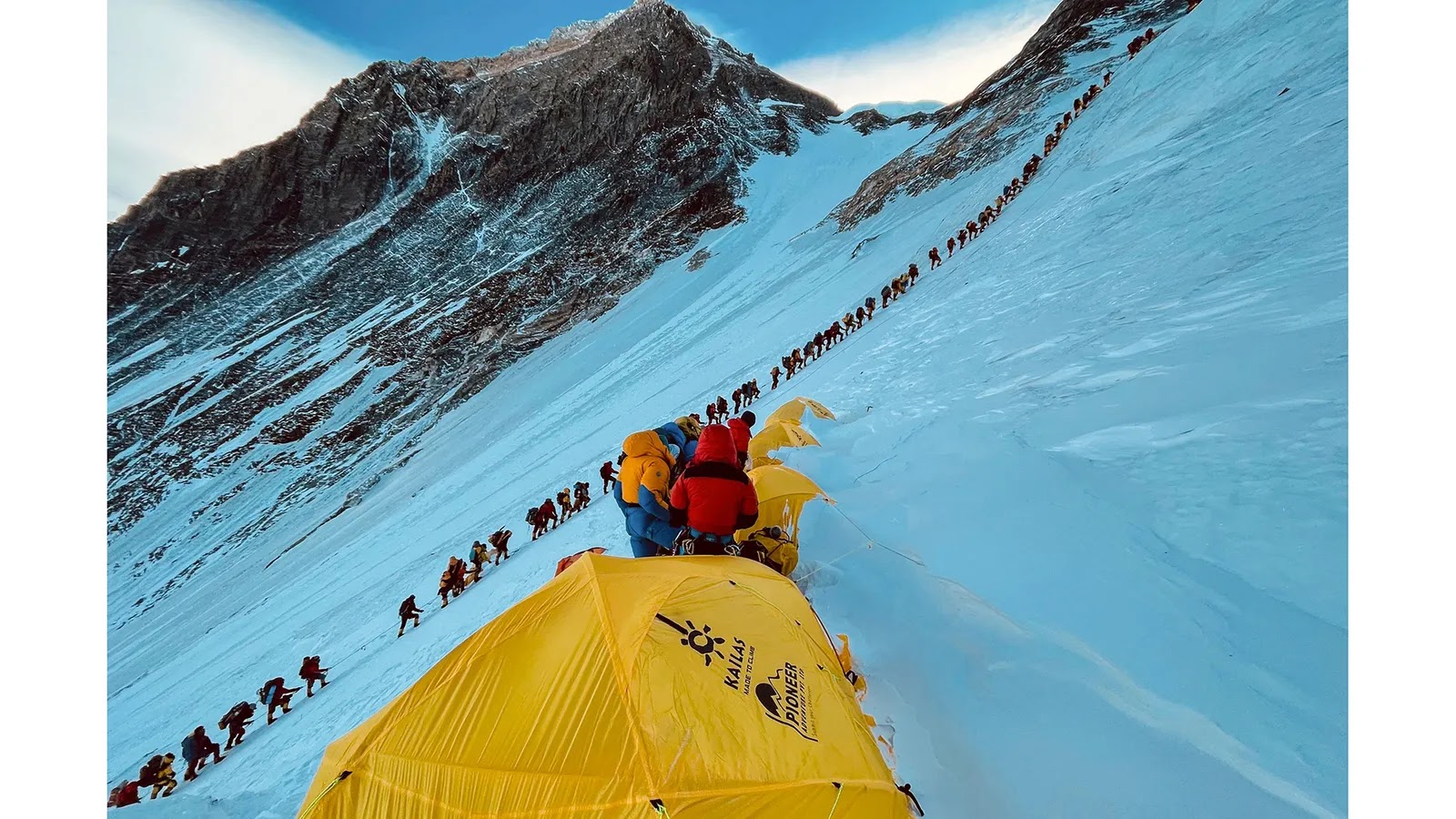 |
The main routes up Mount Everest have now become so popular with climbers that long queues can form (Credit: Lakpa Sherpa/AFP/Getty Images) |
Many of the highest peaks in the world, including Everest, have permanent snow caps that help protect them from this wind-blown barrage. Rock covered in a soft blanket of snow suffers less weathering and erosion than bare rock, says Headley. It also protects the rock from chemical reactions with the air that can gradually degade the minerals in the limestone that comprises much of the uppermost parts of Mount Everest. But there are still places where the rock is exposed to the elements.
"For a tall mountain range, you can basically get to such a steep angle in the rock that it can't actually support ice, and snow, and then you start to get avalanches, and you get bare rock," says Elmore. Rock falls and land slides – a constant hazard on Everest and the surrounding area – both play a role in shaving away at Everest's height, and rivers too. They have been estimated to be cutting gorges into the rock at a rate of between 4-8mm (0.2-0.3in) a year.
But the exact impact erosion has on a mountain's height is still to be understood. Some scientists believe that reducing the weight of a mountain (by taking away the snow, ice and rock it's made of) might actually allow the tectonic plates to push the, now lighter, mountain even further into the sky.
Headley's colleague Terry Pavlis, who was the lead investigator on the St Elias Erosion Tectonics Project (Steep), explains that, on a large scale, "erosion attacking a landscape allows it to rise up".
In some parts of the world, entire landmasses are still rearing up after the last ice age – something known as isostatic rebound. Parts of North America and northern Europe, including Scotland, are rebounding after the rocky crust there was squashed by enormous continental ice sheets that waxed and waned during the Pleistocene. According to one study by researchers at Germany's University of Postdam, up to 90% of the uplift in the European Alps can be explained by this surprisingly elastic response to the end of the ice age. Experts believe similar glacial isostatic rebound may have taken place on the Tibetan Plateau and in the Himalaya as the ice age glaciers receeded – contributing between 1-4mm (0.04-0.16in) a year to the uplift.
"But there's some kind of equilibrium between how fast that landscape can erode and how high those peaks can get," adds Pavlis.
The exact details of this equilibrium are still being explored. In a region like the Appalachians in north-eastern North America, or the Scottish Highlands, erosive forces like rivers and landslides are cutting mountains down lower and lower, Headley says. "But in regions with tectonic activity, the tectonic force can be driving the mountains up slower, faster, or at around the same rate as the erosion is cutting it down. We don't fully understand all the drivers in those types of systems."
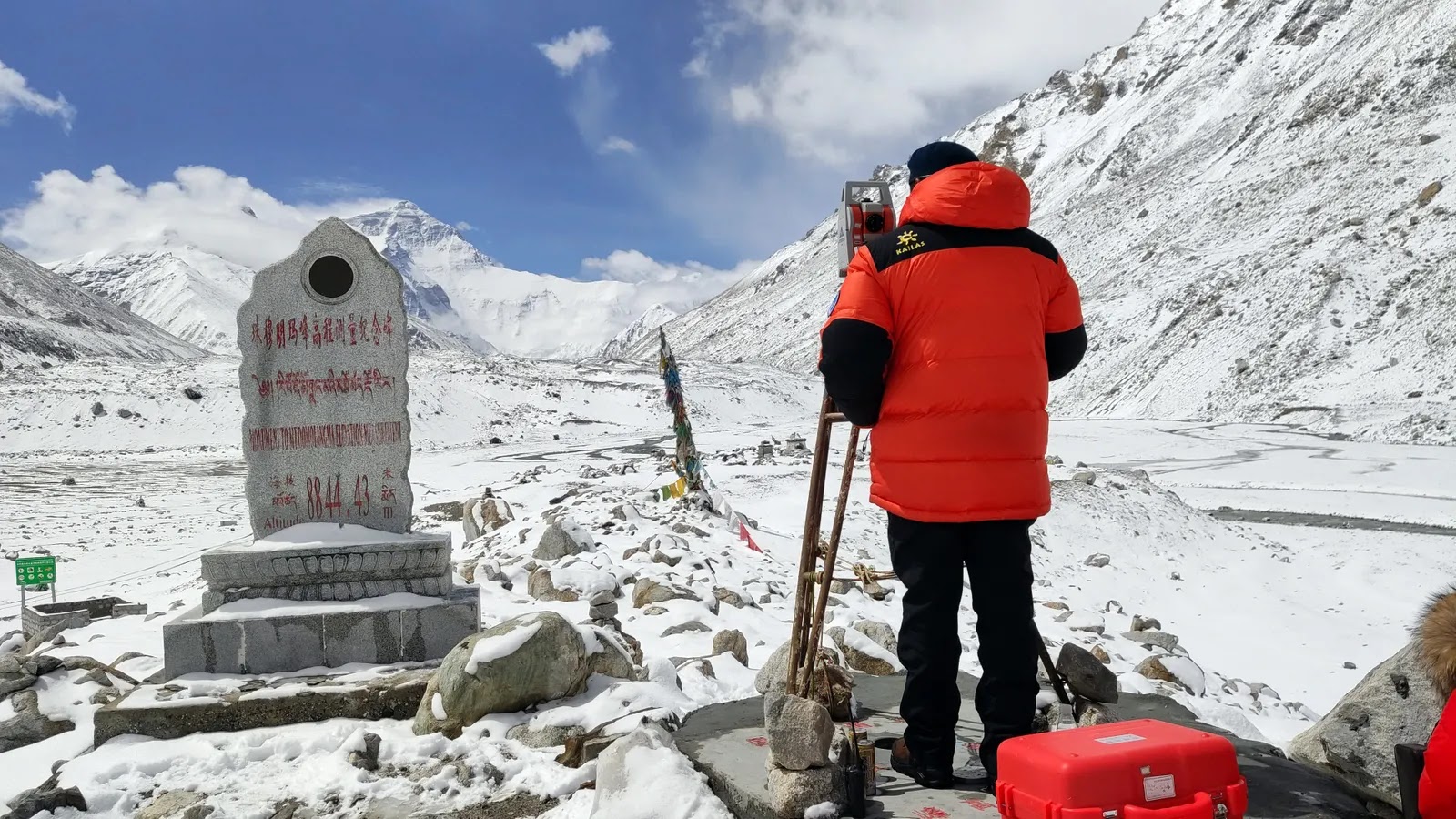 |
The most recent official height for Mount Everest was agreed following Chinese and Nepalese surveying expeditions to the summit (Credit: VCG/Getty Images) |
So how are mountains actually measured nowadays? One of the most common instruments used is the Global Navigation Satellite System (GNSS), which records the precise position of the mountain peak using a network of satellites. GNSS can "measure heights to the millimetre," according to Pavlis. The challenge, for a mountain like Everest, has always been the weight of the equipment. "It's hard enough to get to the peak – try adding a 30lb (13kg) instrument," he says.
A helicopter taxi to the top with the heavy luggage is out of the question – the thin air around Everest's summit means the engine can't produce enough power and there's too much drag from the rotor blades to operate safely. The strong winds and jagged creeks also make touching down anywhere near the summit dangerous. One helicopter pilot did set a world record by touching down briefly on top of Mount Everest in 2005, but only after the manufacturer stripped it bare of every unessential item to make it feather light.
Luckily, GNSS systems have gotten smaller over the years. Now they weigh more like 1.2kg (2.6lbs) and are "about the size of a lunchbox, maybe a little smaller", says Pavlis. But the devices still need batteries, which can struggle in cold temperatures. The average temperature at the summit of Everest during the summer monsoon months is a balmy -19C. And there are other complications too. "There's an antenna that's about, you know, half a metre in diameter. And those have to be set up somehow so that they are absolutely stationary," Pavlis explains.
To gather millimetre-accurate results the instrument then has to record for several hours. In the thin air of Everest's "death zone", operating these instruments can be hazardous for surveyors. Members of a Nepalese expedition to take GNSS measurements on Everest in 2019 spent two hours on the summit – far longer than most who make their way there – after arriving at 03:00 in the pitch black and biting cold.
Another option, often used in addition to GNSS for the most accurate readings, is Ground Penetrating Radar (GPR). "GPR uses radar pulses to image below the surface, so it can tell us the thickness and internal structure of snow and ice overlying the rocks on Everest's summit," says Elmore. "There's something like 4m (13ft) of snow and ice on the top of Mount Everest, but that can change depending on the climate."
The mountain that measures the greatest distance from the centre of Earth to its peak is Chimborazo in Equador, at 10,920m (35,826ft)
While Elmore and her team were conducting their own scientific experiments on Everest they leant the Nepalese expedition a GPR device so they could take measurements from the summit. "It had to be a specific design of GPR, one that was super lightweight so [it could be carried] to the top of Everest, but that also had the right transmitter and receiver to measure the ice," says Elmore. The device had recently been used at the summit of Denali, the tallest mountain in the US, so they knew it was up to the job.
Despite the many hurdles they faced, the Nepalese team's expedition to measure the height of Everest was successful. They had hoped to answer questions about whether a deadly 7.8 magnitude earthquake that hit Nepal in April 2015 had affected Mount Everest's height. Initial reports indicated the mountain had shifted 3cm (1.9in) to the south-west by the large earthquake, which killed 9,000 people and damaged hundreds of thousands of homes, but had not changed its height.
The project, however, soon became muddied with international politics. A few months later a team of Chinese surveyors conducted their own measurements during an expedition from the other side of the mountain. They had their own figure, which didn't include the snow cap. The Nepalese figure, on the other hand, did. In October 2019, the two countries decided to combine their data and in December 2020 they released the figure for the new official height – 8,848.86m (29,032ft), including the snow on top.
As China and Nepal found, deciding exactly what you measure, and how you measure, is fundamental to establishing a mountain's height. For example, to agree upon how tall a mountain is, we must first agree on where the bottom is. But that's not as easy as it might sound.
For centuries mountains have been measured using sea level as the base from where their height is calculated. But the Earth is not perfectly round: it bulges along the equator. And sea level isn't static, it is pulled and changed by our planet's gravity. Plus, Everest isn't sticking out of the ocean, it's nestled among a landscape of other mountains.
Many complex calculations have to be done to establish where sea level would actually be, and Everest's relative height to it. When that starting point is changed, everything changes.
 |
The Himalayas began rising around 45 million years ago as the Indian and Eurasian continental plates collided (Credit: Rik Olde Engberink/Alamy) |
But let's say scientists started their measurements from the core of the planet instead. Everest would no longer be considered the tallest mountain on Earth. The mountain that measures the greatest distance from the centre of Earth to its peak is Mount Chimborazo, in Equador at 10,920m (35,826ft). What about starting from the seabed? The accolade of tallest mountain would then go to Mauna Kea, a volcano in Hawaii that arches 10,000m (32,808ft) from the ocean floor.
Looking beyond our own planet, we can see examples of just how enormous mountains can become. Olympus Mons, a volcano on Mars, towers 21km (19.2 miles) into the sky and stretches 624km (388 miles) wide. It is roughly the size of the state of Arizona. Because gravity on Mars is weaker than on Earth, and because Mars doesn't have tectonic plates shifting and colliding beneath the surface, the ooze of lava that flowed out of the Martian volcano in the planet's past was able to grow to monstrous proportions.
Could Everest become a similar giant? In the 1980s, a researcher at the Cavendish Laboratory in Cambridge, UK, attempted to estimate what such a limit might be on Earth, taking into account the strength of gravity and the strength of the rock underlying the mountain. The calculations, which made "no presensions to serious geophysics" estimated the theoretical maximum height of a mountain range with a granite base – as Mount Everest largely has – to be 45km (28 miles) on Earth.
But there are a number of barriers – apart from our planet's relentless weather – that might stand in the way of this, according to Headley. For starters, "you would eventually run out of your tectonic forces, and then it would stop growing", she says. Scientists believe that eventually the Earth's mantle will cool to such a degree that the planet-wide dance of plate tectonics will end. Until then, earthquakes and landslides will also erode away the mountain too.
"At some point, [the mountain] becomes so steep that it's unstable and chunks start falling off," Elmore says.
With the wind, snow and ice buffeting, cracking and splitting the rock, Everest is unlikely to ever reach the sizes seen on Mars. "We have our weather systems, and weather is really good at creating erosional forces," Headley says. "Basically, the fact that we have water, whether in the form of ice or snow, or just rain, is what really can limit mountain growth."
For now, Everest keeps edging, bit by bit, into the sky as other forces try to tear it down. Elmore's 2019 team discovered global warming was yet another of these, driving considerable thinning of the snow and ice on the upper reaches of the mountain in recent decades and revealing more bare rock to the erosive impacts of weather.
Olympus Mons, a volcano on Mars, towers 21km (19.2 miles) into the sky and stretches 624km (388 miles) wide
Everest is also far from being the fastest-growing mountain on our planet. The closest contender for the top spot is perhaps Nanga Parbat, a neighbour to Everest located in the Pakistani Himalayan range, which is 8,126m (26,660ft) tall and growing at 7mm (0.27in) per year. In 241,000 years it could overtake Everest to be the tallest mountain on Earth, provided rates of erosion don't change.
Others, such as those in the Swiss Alps, are also growing rapidly thanks to an imbalance in the amount of erosion taking place. Scientists found that uplift is more than 50 times faster than any negative effects from erosion here. But the Swiss Alps are far shorter than Mount Everest and most studies suggest the mountains there are currently growing at 2-2.5mm (0.08-0.1 inches) per year.
Meanwhile, Everest retains its allure as a mountain at the extreme of what can be found and endured here on Earth. Its reputation as the highest peak on our planet continues to attract climbers from all over the world, even as its height continues to shift.
Over a video call I ask Billi Bierling, a mountaineering journalist who hiked Everest herself in 2009, whether an extra millimetre, metre or mile higher matters to people like her. She is relaxing on the sofa at her mother's house in Germany, preparing to head back to Nepal for the summer season in March.
"The exact measurement doesn't matter," she says, laughing warmly at my question. "What matters is that it's the highest, and that you go to the highest point. If you're having a bad day, or someone is not very nice to you, or they put you down, you can think to yourself, you know what? I've climbed Everest."
For most who reach the summit, it is simply being there that counts.
(Source: BBC)


