In Mount Everest region, world's highest glaciers are melting, receding
In this photo essay, the editor of the Nepali Times, Kunda Dixit, describes the dramatic changes underway in the ice and snow of the Himalayan Mountains.
For many tourists trekking to Mount Everest Base Camp, the trip is an adventure of a lifetime. The thin clear air, stark landscape and ice-tipped peaks pierce the inky sky providing Instagram backdrops.
However, what is stunning scenery to tourists is for climate scientists an apocalyptic sight. They see dramatic evidence all around of a rapidly warming atmosphere.
Visitors returning to the Everest region after many years will notice changes in the landscape: large lakes where there were none; glacial ice replaced by ponds, boulders and sand; the snowline moving up the mountains; and glaciers that have receded and shrunk.
All these features are visible from ground level right from the start of the trek in Lukla. The banks of the Bhote Kosi, part of the river system that drains the slopes of the Himalayas in Nepal and Tibet, still bear the scars of a deadly flash flood in 1985 that washed off a long section of the Everest Trail and the hydropower plant in the village of Thame. The flood was caused by an avalanche into the Dig Tso, a glacial lake.
Further up, near the village of Tengboche, the Imja Khola bears signs of another huge glacial lake outburst flood that thundered down the western flank of Ama Dablam in 1977. And below the formidable south face of Lhotse is Imja Tso, a lake 2 kilometers long that has formed and grown in the last 30 years. It does not exist on trekking maps from the 1980s. All these lakes were formed and enlarged as a result of global warming melting the ice.
Imja Tso, a glacial lake, did not exist on trekking maps 30 years ago. Today it is 2 kilometers long and 1 kilometer wide. Credit: Kunda Dixit/Nepali Times
"When I look at the Nepal Himalaya, we can see this is global climate change impact on fast-forward," said Dipak Gyawali of the Nepali Water Conservation Foundation and the Nepal Academy of Science and Technology.
Green and blue meltpools on the North Ama Dablam Glacier, where the vanishing icefall has exposed the eroded bedrock below. Credit: Kunda Dixit/Nepali Times
The Lobuje Icefall is now a hanging glacier, having retreated above the cliff. Credit: Kunda Dixit/Nepali Times
The terminal moraine of the Khumbu Glacier looms 400 meters above Dughla, a rest stop for climbers. This is the debris bulldozed down from Mount Everest and surrounding peaks over millions of years and represents the extent of the glacier's advance in the last Ice Age. Today, the surface ice on the world's highest glacier is all but gone due to natural and anthropogenic warming.
Khumbu Glacier, the world's highest glacier, has retreated as the planet has warmed. Its lower portion is largely covered by debris. Credit: NASA Landsat 8 image by Jesse Allen and Robert Simmon
For a dramatic glimpse of how global warming is changing the Himalayan landscape, there is nothing like the aerial perspective. The barren beauty foretells of a time when this terrain will be stripped of much of what remains of its ice cover.
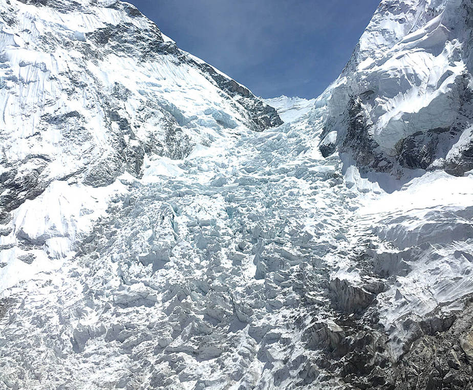
The Khumbu Icefall carries debris and ice from the Western Cwm to the Khumbu Glacier, 1,000 meters below. Credit: Kunda Dixit/Nepali Times
The Khumbu Icefall funnels ice from the Western Cwm below Everest, Lhotse and Nuptse to the glacier below. The ice here has receded at an average of 30 meters per year in the past 20 years, but it has also shrunk vertically, losing up to 50 meters in thickness. Everest Base Camp was at 5,330 meters when Sir Edmund Hillary and Tenzing Norgay climbed Mount Everest in 1953; today it is at 5,270 meters.
A map shows base camp and how a key climbing route up Mount Everest changed after a deadly avalanche in 2014. Credit: Gregory Leonard, with data by Digital Globe and Mark Fahey/USGS, via NASA
The glacier is also getting flatter: the darker debris makes the ice beneath melt faster near Base Camp, but the thicker layers of boulders and sand further down insulate the ice. Glaciologists say this flatter profile means the ice moves slower, leading to more ponding and more rapid melting of the ice underneath.
The velocity of the glacier is about 70 meters per year at Base Camp, and it slows to about 10 meters per year further below. It's zero at the terminus at 4,900 meters. This means the ice is decelerating as it is squeezed, and the pressure is being released by the melting of the ice mass.
Khumbu Glacier is receding at about 30 meters per year and shrinking: Base Camp is now 50 meters lower than when Sir Edmund Hillary and Tenzing Norgay climbed Mount Everest in 1953. Credit: Kunda Dixit/Nepali Times
Researchers monitoring the supraglacial ponds say their area has grown by 70 percent in the past 10 years alone. The ponds are fringed by ice cliffs and caves that accelerate the melting. The melted ice has carved an outflow channel through the left lateral moraine, so there is no large glacial lake on the Khumbu like elsewhere in Nepal.
Scientists conclude that the Khumbu Glacier is not about to vanish, and the Icefall is not going to turn into a waterfall any time soon. However, the permanent ice catchment of the glacier above 6,000 meters could start to deplete under a worst-case scenario of 5 degrees Celsius warming.


No comments:
Post a Comment